
Page 180 - :: สมุดภาพกรมทางหลวง เล่ม ๒ ::
P. 180
ตรวจงานการสร้างทางหลวงในภาคใต้ พ.ศ. ๒๔๙๓
The 1950 Inspection Tour of National Highways in the South
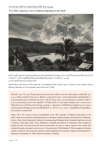
แม่น�้ากระบุรี (คอคอดกระ) ริมถนนเพชรเกษม บริเวณบ้านทับหลี ต�าบลมะมุ อ�าเภอกระบุรี จังหวัดระนอง มีค�าบรรยายก�ากับ
ภาพเดิมว่า “แม่น�้ากระบุรีที่ทับหลี ฝั่งตรงข้ามที่เห็นเป็นแดนพะม่า” ถ่ายเมื่อ พ.ศ. ๒๔๙๒
(ภาพจากส�านักหอจดหมายเหตุแห่งชาติ)
Kraburi River, also known as Kho Khot Kra, on Phetkasem Road, at Ban Thap Li, Tambon Lamu, Amphoe Kraburi,
Ranong. Myanmar is on the opposite bank of the river in 1950.
ตั้งแต่หน้า ๑๗๘ ถึง ๑๙๗ คือชุดภาพคณะนายช่างของกรมทางเดินทางมาตรวจการสร้างเส้นทางภาคใต้ เมื่อ พ.ศ.
๒๔๙๓ บันทึกภาพโดยเจ้ากาวิละวงศ์ ณ เชียงใหม่ นายช่างประจ�ากรมทาง (ต�าแหน่งในขณะนั้น) โดยเริ่มต้นเดินทาง
มาตามถนนเพชรเกษม ผ่านจังหวัดระนอง พังงา กระบี่ ตรัง พัทลุง สงขลา และนครศรีธรรมราช ภายหลังการเดินทาง
มาตรวจงานของคณะนายช่างกรมทางชุดนี้แล้ว ท�าให้รัฐบาลเห็นว่าการสร้างเส้นทางในภูมิภาคต่างๆ ของประเทศ
ได้เชื่อมโยงกันอย่างทั่วถึงในแต่ละจังหวัดรัฐบาลจอมพล ป. พิบูลสงคราม จึงได้มีมติประกาศให้ขนานนามทางหลวง
แผ่นดินและสะพานส�าคัญของกรมทางหลวงขึ้นเมื่อวันที่ ๑๐ ธันวาคม พ.ศ. ๒๔๙๓ ภาพชุดนี้ทั้งหมดเป็นสมบัติของ
ส�านักหอจดหมายเหตุแห่งชาติ
Pages 178 to 197 contain a series of photographs of the 1950 inspection of highway constructions in the
South. Taken and compiled by Chao Kawilawong na Chiangmai, Highway Engineer at Department of Highways.
Division, Public Works Department. Starting from traveling along Phetkasem Road. Passing through the provinces
of Ranong, Phang Nga, Krabi, Trang, Phatthalung, Songkhla and Nakhon Si Thammarat. After traveling to
inspect the work, the government see that the construction of routes in various regions of the country was
already thoroughly connected in each province. The government of Field Marshal P. Phibunsongkhram therefore
passed a resolution announcing the naming of national highways and important bridges of the Department of
Highways on December 10, 1950. (National Archives of Thailand)
178 I 178