
Page 129 - :: สมุดภาพกรมทางหลวง เล่ม ๒ ::
P. 129
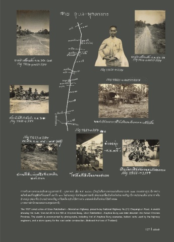
การสร้างทางหลวงแผ่นดินสายอุบลราชธานี - มุกดาหาร เมื่อ พ.ศ. ๒๔๘๐ (ปจจุบันคือทางหลวงแผ่นดินหมายเลข ๒๑๒ ถนนชยางกูร) มีภาพร่าง
สเก็ตช์แผนที่ระบุพิกัดกิโลเมตรที่ ๕๕ ถึง ๑๐๐ ในอ�าเภอบุ่ง จังหวัดอุบลราชธานี (ต่อมาแยกขึ้นเป็นจังหวัดอ�านาจเจริญ) มีภาพประกอบคือ บรรยากาศใน
อ�าเภอบุ่ง (ต่อมาคือ อ�าเภออ�านาจเจริญ) เกวียนที่นายช่างใช้ตรวจงาน และแหล่งหินที่จะน�ามาใช้สร้างถนน
(ภาพจากส�านักหอจดหมายเหตุแห่งชาติ)
The 1937 construction of Ubon Ratchathani - Mukdahan Highway, present-day National Highway No.212 Chayangkun Road. A sketch
showing the route, from km.55 to km.100 at Amphoe Bung, Ubon Ratchathani. Amphoe Bung was later elevated into Amnat Charoen
Province. The sketch is accompanied by photographs, including that of Amphoe Bung sceneries, bullock carts used by the highway
engineers, and a stone quarry for the road under construction. (National Archives of Thailand)
127 I 127