
Page 130 - :: สมุดภาพกรมทางหลวง เล่ม ๒ ::
P. 130
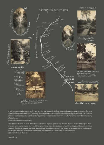
การสร้างทางหลวงแผ่นดินสายอุบลราชธานี - มุกดาหาร เมื่อ พ.ศ. ๒๔๘๐ (ปจจุบันคือทางหลวงแผ่นดินหมายเลข ๒๑๒ ถนนชยางกูร) มีภาพร่าง
สเก็ตช์แผนที่ระบุพิกัดกิโลเมตรที่ ๑๐๐ ในอ�าเภอบุ่ง จังหวัดอุบลราชธานี (ต่อมาแยกขึ้นเป็นจังหวัดอ�านาจเจริญ) ถึงกิโลเมตรที่ ๑๕๐ ในอ�าเภอ
มุกดาหาร จังหวัดนครพนม (ต่อมาแยกขึ้นเป็นจังหวัดมุกดาหาร) มีภาพประกอบคือ การสร้างถนนผ่านพื้นที่ป่าระหว่าง และการส�ารวจหาแหล่งหิน
เพื่อใช้สร้างถนน
(ภาพจากส�านักหอจดหมายเหตุแห่งชาติ)
The 1937 construction of Ubon Ratchathani - Mukdahan Highway, present-day National Highway No.212 Chayangkun Road.
A sketch showing the route, from km.100 Amphoe Bung, Ubon Ratchathani, to km.150 at Amphoe Mukdahan, Nakhon
Phanom. Amphoe Mukdahan was later elevated into Mukdahan Province. The sketch is accompanied by photographs,
including that of the road construction to forested areas, and the search for a stone quarry for road construction.
(National Archives of Thailand)
128 I 128