
Page 131 - :: สมุดภาพกรมทางหลวง เล่ม ๒ ::
P. 131
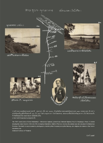
การสร้างหลวงแผ่นดินสายอุบลราชธานี - มุกดาหาร เมื่อ พ.ศ. ๒๔๘๐ (ปจจุบันคือทางหลวงแผ่นดินหมายเลข ๒๑๒ ถนนชยางกูร) มีภาพร่าง
สเก็ตช์แผนที่ระบุพิกัดกิโลเมตรที่ ๑๔๐ ถึง ๑๖๕ ในอ�าเภอมุกดาหาร จังหวัดนครพนม (ต่อมาแยกขึ้นเป็นจังหวัดมุกดาหาร) มีภาพประกอบคือ
ทิวทัศน์ริมแม่น�้าโขง และศาสนสถานในฝ่งอินโดจีน
(ภาพจากส�านักหอจดหมายเหตุแห่งชาติ)
The 1937 construction of Ubon Ratchathani - Mukdahan Highway, present-day National Highway No.212 Chayangkun Road. A sketch
showing the route, from km.140 to km.165, in Amphoe Mukdahan, Nakhon Phanom. Amphoe Mukdahan was later elevated into Mukdahan
Province. The sketch is accompanied by photographs, including that of scenery along the Mekong, and religious structures on the French
Indochine side.
(National Archives of Thailand)
129 I 129