
Page 124 - :: สมุดภาพกรมทางหลวง เล่ม ๒ ::
P. 124
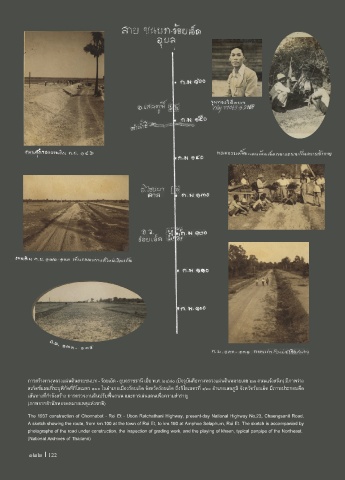
การสร้างทางหลวงแผ่นดินสายชนบท - ร้อยเอ็ด - อุบลราชธานี เมื่อ พ.ศ. ๒๔๘๐ (ปจจุบันคือทางหลวงแผ่นดินหมายเลข ๒๓ ถนนแจ้งสนิท) มีภาพร่าง
สเก็ตช์แผนที่ระบุพิกัดที่กิโลเมตร ๑๐๐ ในอ�าเภอเมืองร้อยเอ็ด จังหวัดร้อยเอ็ด ถึงกิโลเมตรที่ ๑๖๐ อ�าเภอเสลภูมิ จังหวัดร้อยเอ็ด มีภาพประกอบคือ
เส้นทางที่ก�าลังสร้าง การตรวจงานดินปรับพื้นถนน และการเล่นแคนเพื่อความส�าราญ
(ภาพจากส�านักหอจดหมายเหตุแห่งชาติ)
The 1937 construction of Chonnabot - Roi Et - Ubon Ratchathani Highway, present-day National Highway No.23, Chaengsanit Road.
A sketch showing the route, from km.100 at the town of Roi Et, to km.160 at Amphoe Selaphum, Roi Et. The sketch is accompanied by
photographs of the road under construction, the inspection of grading work, and the playing of khaen, typical panpipe of the Northeast.
(National Archives of Thailand)
122 I 122