
Page 123 - :: สมุดภาพกรมทางหลวง เล่ม ๒ ::
P. 123
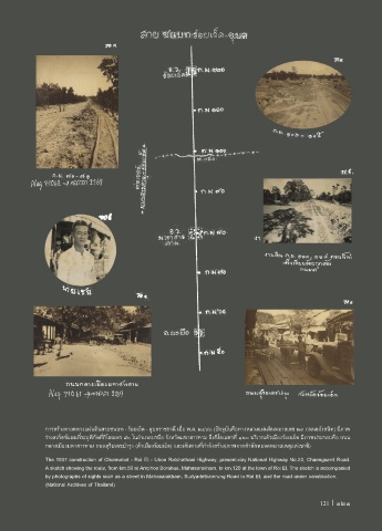
การสร้างทางหลวงแผ่นดินสายชนบท - ร้อยเอ็ด - อุบลราชธานี เมื่อ พ.ศ. ๒๔๘๐ (ปจจุบันคือทางหลวงแผ่นดินหมายเลข ๒๓ ถนนแจ้งสนิท) มีภาพ
ร่างสเก็ตช์แผนที่ระบุพิกัดที่กิโลเมตร ๕๐ ในอ�าเภอบรบือ จังหวัดมหาสารคาม ถึงกิโลเมตรที่ ๑๒๐ บริเวณตัวเมืองร้อยเอ็ด มีภาพประกอบคือ ถนน
กลางเมืองมหาสารคาม ถนนสุริยเดชบ�ารุง (ตัวเมืองร้อยเอ็ด) และเส้นทางที่ก�าลังสร้าง(ภาพจากส�านักหอจดหมายเหตุแห่งชาติ)
The 1937 construction of Chonnabot - Roi Et - Ubon Ratchathani Highway, present-day National Highway No.23, Chaengsanit Road.
A sketch showing the route, from km.50 at Amphoe Borabue, Mahasarakham, to km.120 at the town of Roi Et. The sketch is accompanied
by photographs of sights such as a street in Mahasarakham, Suriyadetbamrung Road in Roi Et, and the road under construction.
(National Archives of Thailand)
121 I 121