
Page 95 - :: สมุดภาพกรมทางหลวง เล่ม ๒ ::
P. 95
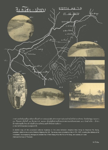
ภาพร่างสเก็ตช์แผนที่แนวเส้นทางที่จะสร้างทางหลวงแผ่นดิน ส�ารวจระหว่างอ�าเภอบ้านโฮ่งถึงอ�าเภอป่าซาง จังหวัดล�าพูน ระยะทาง
๔๓ กิโลเมตร เมื่อวันที่ ๑๗ มีนาคม พ.ศ. ๒๔๗๙ (ปจจุบันคือส่วนหนึ่งของทางหลวงแผ่นดินหมายเลข ๑๐๖ ช่วงบ้านโฮ่ง - ป่าซาง
มีภาพประกอบคือ วัดฉางข้าวน้อยใต้ (อ�าเภอป่าซาง) และทิวทัศน์ระหว่างเส้นทาง
(ภาพจากส�านักหอจดหมายเหตุแห่งชาติ)
A sketch map of the proposed national highway in the area between Amphoe Ban Hong to Amphoe Pa Sang,
Lamphun, which is now a part of National Highway No.106. The survey was conducted on March 17th, 1937, covering the distance of 43
milometers. Accompanying photographs include that of Wat Chang Khao Noi Tai in Pa Sang, and scenery en route.
(National Archives of Thailand)
93 I 93