
Page 94 - :: สมุดภาพกรมทางหลวง เล่ม ๒ ::
P. 94
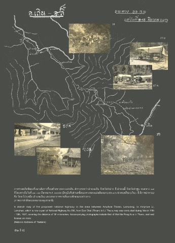
ภาพร่างสเก็ตช์แผนที่แนวเส้นทางที่จะสร้างทางหลวงแผ่นดิน ส�ารวจระหว่างอ�าเภอเถิน จังหวัดล�าปาง ถึงอ�าเภอลี้ จังหวัดล�าพูน ระยะทาง ๓๙
กิโลเมตร เมื่อวันที่ ๑๑ - ๑๓ มีนาคม พ.ศ. ๒๔๗๙ (ปจจุบันคือส่วนหนึ่งของทางหลวงแผ่นดินหมายเลข ๑๐๖ ช่วงดอนไชย (เถิน) - ลี้ มีภาพประกอบ
คือ วัดนาโป่งเหนือ (อ�าเภอเถิน) และบรรยากาศการเดินทางพักแรมระหว่างทาง
(ภาพจากส�านักหอจดหมายเหตุแห่งชาติ)
A sketch map of the proposed national highway in the area between Amphoe Thoen, Lampang, to Amphoe Li,
Lamphun, which is now a part of National Highway No.106, from Don Chai (Thoen) to Li. The survey was conducted during March 11th
- 13th, 1937, covering the distance of 39 milometers. Accompanying photographs include that of Wat Na Pong Nua in Thoen, and rest
houses en route.
(National Archives of Thailand)
92 I 92