
Page 93 - :: สมุดภาพกรมทางหลวง เล่ม ๒ ::
P. 93
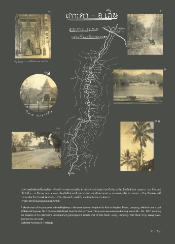
ภาพร่างสเก็ตช์แผนที่แนวเส้นทางที่จะสร้างทางหลวงแผ่นดิน ส�ารวจระหว่างอ�าเภอเกาะคาถึงอ�าเภอเถิน จังหวัดล�าปาง ระยะทาง ๘๔ กิโลเมตร
เมื่อวันที่ ๖ - ๙ มีนาคม พ.ศ. ๒๔๗๙ (ปจจุบันคือส่วนหนึ่งของทางหลวงแผ่นดินหมายเลข ๑ ถนนพหลโยธิน ช่วงเกาะคา - เถิน) มีภาพสถานที่
ประกอบคือ วิหารวัดเจดีย์หลวงล�าปาง วิหารวัดจอมปิง แม่น�้าวัง และทิวทัศน์ระหว่างเส้นทาง
(ภาพจากส�านักหอจดหมายเหตุแห่งชาติ)
A sketch map of the proposed national highway in the area between Amphoe Ko Kha to Amphoe Thoen, Lampang, which is now a part
of National Highway No.1 Phahonyothin Road, from Ko Kha to Thoen. The survey was conducted during March 6th - 9th, 1937, covering
the distance of 84 milometers. Accompanying photographs include that of Wat Chedi Luang, Lampang, Wat Chom Ping, Wang River,
and scenery en route.
(National Archives of Thailand)
91 I 91