
Page 75 - :: สมุดภาพกรมทางหลวง เล่ม ๒ ::
P. 75
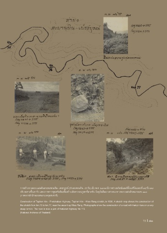
การสร้างทางหลวงแผ่นดินสายตะพานหิน - เพชรบูรณ์ (ช่วงตะพานหิน - เขารัง) เมื่อ พ.ศ. ๒๔๗๙ มีภาพร่างสเก็ตช์แผนที่ตั้งแต่กิโลเมตรที่ ๗๕ ถึง ๗๗
บริเวณทางขึ้นเขารัง แสดงภาพการขุดสกัดหินเพื่อสร้างเส้นทางบนภูเขาที่ลาดชัน ปจจุบันคือบางส่วนของทางหลวงแผ่นดินหมายเลข ๑๑๓
(ภาพจากส�านักหอจดหมายเหตุแห่งชาติ)
Construction of Taphan Hin - Phetchabun Highway, Taphan Hin - Khao Rang stretch, in 1936. A sketch map shows the construction of
the stretch from km.75 to km.77, near the ascent up Khao Rang. Photographs show the construction of a road with hairpin turs on a very
steep terrain. The road is now a part of National Highway No.113.
(National Archives of Thailand)
73 I 73