
Page 71 - :: สมุดภาพกรมทางหลวง เล่ม ๒ ::
P. 71
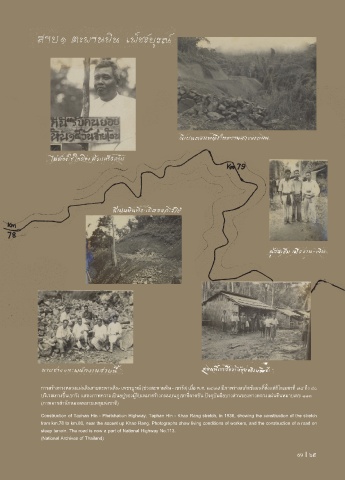
การสร้างทางหลวงแผ่นดินสายตะพานหิน- เพชรบูรณ์ (ช่วงตะพานหิน - เขารัง) เมื่อ พ.ศ. ๒๔๗๙ มีภาพร่างสเก็ตช์แผนที่ตั้งแต่กิโลเมตรที่ ๗๘ ถึง ๘๐
บริเวณทางขึ้นเขารัง แสดงภาพความเป็นอยู่ของผู้รับเหมาสร้างถนนบนภูเขาที่ลาดชัน ปจจุบันคือบางส่วนของทางหลวงแผ่นดินหมายเลข ๑๑๓
(ภาพจากส�านักหอจดหมายเหตุแห่งชาติ)
Construction of Taphan Hin - Phetchabun Highway, Taphan Hin - Khao Rang stretch, in 1936, showing the construction of the stretch
from km.78 to km.80, near the ascent up Khao Rang. Photographs show living conditions of workers, and the construction of a road on
steep terrain. The road is now a part of National Highway No.113.
(National Archives of Thailand)
69 I 69