
Page 151 - :: สมุดภาพกรมทางหลวง เล่ม ๒ ::
P. 151
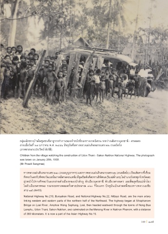
กลุ่มเด็กชาวบ้านในชุมชนที่มาดูการท�างานของเจ้าหน้าที่กองทางภาคอิสาณ ระหว่างเส้นทางอุดรธานี - สกลนคร
ถ่ายเมื่อวันที่ ๒๙ มกราคม พ.ศ. ๒๔๘๑ ปจจุบันคือทางหลวงแผ่นดินหมายเลข ๒๒ ถนนนิตโย
(ภาพจากนายประวิทย์ สังข์มี)
Children from the village watching the construction of Udon Thani - Sakon Nakhon National Highway. The photograph
was taken on January 29th, 1939.
(Mr Prawit Sangmee)
ทางหลวงแผ่นดินหมายเลข ๒๑๐ (ถนนบุญยาหาร) และทางหลวงแผ่นดินหมายเลข ๒๒ (ถนนนิตโย) เป็นเส้นทางที่เชื่อม
ทิศตะวันตกกับทิศตะวันออกในภาคอีสานตอนเหนือ มีจุดเริ่มต้นที่สะพานสีห์พนม (ริมแม่น�้าเลย) ในอ�าเภอวังสะพุง จังหวัดเลย
มุ่งหน้าไปทางทิศตะวันออกผ่านตัวเมืองหนองบัวล�าภู ตัวเมืองอุดรธานี ตัวเมืองสกลนคร และสิ้นสุดริมแม่น�้าโขง
ในตัวเมืองนครพนม รวมระยะทางตลอดทั้งสายประมาณ ๓๖๐ กิโลเมตร ปจจุบันเป็นส่วนหนึ่งของทางหลวงเอเชีย
สาย ๑๕ (AH15)
National Highway No.210, Bunyahan Road, and National Highway No.22, Nittayo Road, are the main artery
linking western and eastern parts of the northern half of the Northeast. The highway began at Sihaphanom
Bridge on Loei River, Amphoe Wang Saphung, Loei, then headed eastward through the towns of Nong Bua
Lamphu, Udon Thani, Sakon Nakhon, and culminated on the Mekong River in Nakhon Phanom, with a distance
of 360 kilometers. It is now a part of the Asian Highway No.15.
149 I 149